| 
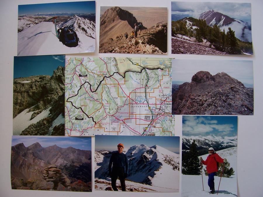
Great Lost Divide, photos by Rick Baugher
Clockwise from bottom center. Black line on locater map shows the Great
Lost Divide. All photos by Rick Baugher.
The author on Fishpole Peak 10480', view to Pion and Eer, 2000.
Trails End Peak 10660' Boulder Mtns view to Perkins, Kent, Ryan, 2003.
Bad Rock Peak 11953' Crux on the easy side of this LRR bad boy, 1993.
West Slide Story 10260~ Boulder Mtns view east to LRR, 2005.
Lopez party ascending Mt Breitenbach, a major triple divide on the GLD,
1991.
Bear Mountain 10744' Lemhi Range, 1997.
Tuscany Peak 10776' Beaverhead Mtns, on the GLD & CD, Mont & Ida, 2001.
Divide Creek Peak 9768' Chuck Ferguson & Eighteenmile Peak, 1996.
The author has visited 97 summits on Idaho's Great Lost Divide over a
27 year period.
Rick Baugher
Jan 29,2008
| The Great Lost Divide unites Idaho's high peaks & ranges and offers world class challenge and solitude for those mountain lovers wishing to tackle all or part of it.
America's premier hiking trails, the PCT, CDT, and AT, are designed to follow watershed divides. The Great Lost Divide does the same thing by following the orographic boundary that separates Idaho's 6 "lost rivers" from the corresponding Pacific and Atlantic waters. Surface waters in the Lost Rivers system don't make it directly to the ocean, but rather sink into the lavas of the Snake River Plain. These 6 streams from west to east are: Big Lost River, Little Lost River; Birch, Medicine Lodge, Beaver, and Camas Creeks.
Explorer John C. Fremont spent much of the 1840's delineating the Great Basin, a portion of which lies in southeastern Idaho. The Great Lost Basin, similar to the Great Basin, is a separate entity to the north, bounded by the Columbia and Missouri watersheds.
The Great Lost Divide traces a ragged letter C (or the outline of a sleeping wolf-take your choice) through the heart of Idaho's east central mountains, touching the counties of Butte, Blaine, Custer, Lemhi, Clark, and Beaverhead in Montana. It passes through Sawtooth, Challis, Targhee, and Beaverhead National Forests, as well as tracts of BLM land.
From US Highway 20/26/93 at Craters of the Moon National Monument the GLD follows the crest of the Pioneer Mountains northwest, over Hyndman Peak, and into the Boulder Mountains. At Ryan Peak it turns northeast, later transecting the Lost River and Lemhi Ranges. Along the way it crosses Idaho's highest point, Borah Peak el 12662'. At Eighteenmile Peak in the Beaverhead Mountains the GLD meets the Continental Divide and waters of the Atlantic. This joint divide proceeds east for 91 miles to Walking Fish Mountain where the Great Lost Divide ends and Atlantic & Pacific are reunited.
Here's the challenge. If one were to stay precisely on the GLD for its entirety a smorgasbord of about 102 summits would be ascended, including 7 of Idaho's 9 twelvers. Several of its 10 and 11 thousand footers were only recently climbed. It is believed there are still two peaks on the route that have never been climbed. For certain, by following the true divide several new route first ascents could be put up by the intrepid climber. You will come to understand that Idaho has not been "climbed out".
The only part of the GLD that has a nearby footpath of any length is in the east, where the Continental Divide Trail can be followed. The southernmost Pioneer, and northeastern Boulder sections offer reasonably mellow off trail hiking. Much of the GLD, however, runs "against the grain" of the mountain ranges it traverses, and is thus reluctant to offer the mountaineer a line of weakness.
Of course, you could take a short cut, hop in your car, and drive 2 hours from Craters to Island Park and be done with it. Just depends on what kind of journey you want to take. For those that want to take Idaho's hard haute route here's a Great Lost Divide visual.
|