| 
Pion and Eer Peaks, photo by Rick Baugher
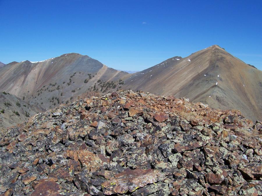
From the likely untrodden summit of Argosy Peak el 10377' the view is
NE across the head of Argosy Creek. Pion 10680' is on the left. The
1934 GLO post is just to the right of this summit. Eer 10744' is the
pointed peak on the far right. Note the multicolored rhyolite and
andesite rockbands characteristic of this mineralized area. Motorists
travelling US Highway 20/26/93 from Carey to Craters get a brief
tantalizing view of this 3 peak cluster from Fish Creek opening. Photo
date 9/28/06.
| Pion and Eer or Pion Error
By September 1994 my Triangulation Station Recovery Project was coming along well. I had visited most of the 150 Idaho mountain top triangulation stations occupied by USGS surveyor Thomas More Bannon from 1912-1915. The goal here was to follow in the explorer's footsteps and to make a photographic record of his work.
I was particularly excited about visiting his station Pion on the main crest of the southern Pioneer Mountains. This station had for some reason become lost, for it doesn't appear on any of the modern maps. Maybe, just maybe, I'd find things untouched since Bannon was here in 1915.
Bannon's field notes for Pion state "On the west of the last two big dome-shaped mountains on the divide between Antelope and Muldoon Creeks...... Station mark: small monument".
These two big peaks have elevations of 10680' and 10744' and are aligned north-south. The taller one lies one half mile further south. In fact, from this summit you could look east, west, and anywhere south and not find a higher peak in Idaho. This is where I got screwed up. I assumed this taller peak was the Bannon station Pion.
I arrived first at 10680' after discovering a neat line of weakness through the peak's precipitous north facing side. The summit had obviously been disturbed but there was no real cairn, so I built one. Shortly after leaving this summit and now heading south toward the higher peak I came across a General Land Office section post dated 1934.
Upon arriving at 10744' I soaked in the fabulous panoramic vista. But something was wrong. This was an untouched summit. Where was the Bannon signal? I dutifully built a "small monument' and left a register proclaiming this to be the T.M. Bannon station Pion. I then retraced my route back over 10680' and out the way I came to the Left Fork Iron Bog trailhead.
Back at home that night, I poured over all the old maps. Station Pion had to be the peak nearest the GLO post. Peak 10680' was Pion. And what of 10744'? These surveyors loved to use catchy foreshortened words- how about 'Eer' as in PionEer. Then again, after the mix up it could be called Err as in Error.
If you're the next one up there, please correct the summit register.
Every outing should have a learning experience. The moral of this story: When in the mountains carry with you the resources you need to get the job done.
|
| 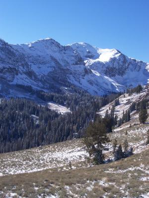
Pion Peak, photo by Rick Baugher
|
Look how the season has changed in less than two weeks. This view is
SW across the Left Fork Iron Bog Creek to the dome-shaped Pion el
10680'. A good way to climb this peak is to head up the left hand side
of this creek bottom. Shortly before reaching the main crest headwall,
turn left and ascend a side canyon. Hunt right for a cleft cutting
through steep rock to the gentler hanging slope high on the peak. In
this photo you can't see the side canyon, but the cleft is visible as a
dark angled gash leading to the lower left of the sunny snowfield.
Photo date 10/11/06.
Rick Baugher
Feb 16, 2008
|