| 
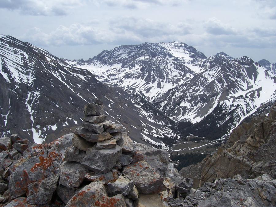
View south to USGS "Lightkeeper" Peak, showing north aspect, from
Longswauger Peak 10648', high above Long Lost Creek on 5/18/07.
Rick Baugher.
| The story of Idaho's highest elevener began about 5 million years ago, when the mountain reached an approximation of its current height.
However, this smunched layer cake of limestone we know as USGS Peak, elevation 11982', didn't begin its human history until 1934-35.
Lee Morrison, of Sacramento, Cal, started with the United States Geological Survey ca1905 as an Assistant Topographer. By the time Morrison was placed in charge of topographic work on the Borah Peak 30 minute quadrangle in 1934, he was one of the USGS's top alpine surveyors. Morrison, in the course of his work, had climbed many difficult mountains in the American West. For instance, he rated his
1934 ascent of Borah Peak as "moderate to stiff" and took his dog Spotty Bruce to its summit for a first canine ascent. Yet, by all indications he did not climb USGS Peak. It is believed he made it to the point later called Castle Peak 10957' and was stopped on USGS's difficult NW ridge/face (an ascent of this route has yet to be reported). Morrison did, however, take an elevation reading by theodolite & plane table of exactly 12000'. This is the elevation that appeared on the completed Borah Peak map of 1935. Thus Idaho's highest elevener for a period of 32 years was known as the state's lowest twelver.
In the mid 1930's Francis B. Laney, the esteemed Chair of the University of Idaho Geology Department, was asked to come up with names for the state's newly discovered twelve thousand foot mountains. He named four: Bell (now known as Mt Idaho), Sacajawea (Mt Church), Hawley (Mt Breitenbach), and Dorion (Lost River Mtn), but Peak 12000' remained unnamed until 1967.
Jim Tennent of the US Coast & Geodetic Survey came to the Mackay area in 1965 to survey part of the new Massacre Mtn 7.5 minute quad. He and his men, called Lightkeepers, surveyed in a time honored way- at night.
By lighting and sighting flares on mountain top triangulation stations in darkness, daylight atmospheric interference could be avoided. They called their triangulation station McCaleb and placed a USCGS iron post benchmark, stamped 1965, on the summit. The Massacre Mtn map, published in 1967, shows this name with an elevation of 11982'.
Why McCaleb when the 11682' summit 1.5 miles to the south was already named McCaleb (since 1914 by the USGS)? Perhaps the Coast surveyors thought the highest point should carry the peak name. Perhaps it was an issue of pride and rivalry among competing Federal land survey agencies?
By 1992 Reed Nielsen wanted to sell his ranch on Lower Cedar Creek. He had worked the land at the base of Mt McCaleb for 47 years, and none of his 13 children wanted to run the operation. It was Reed's dad who had built the dam and irrigation ditches to harness the stream as it poured out of the Lost River Range.
I met Reed Neilsen Aug 15, 1992, and first of all, it's Nielsen Ditch not Nielson as the maps show it. Had he been to the top of USGS Peak as I called it? No, but he had been to Hole in the Rock where most of the 40cfs flow of Lower Cedar Creek gushes out of the canyon sidewall. Had he heard, I asked, of anyone climbing USGS Peak? His surprising answer was NO! As he recounted, back in 1965 Jim Tennent , crew & gear, were transported to the summit by helicopter.
Swirling clouds and raindrops chased me up and down the south ridge of USGS Peak that Aug 15. The summit was a littered mess of survey paraphernalia, mostly spent battery cores from the flares used by the Coast Survey men. How ironic this peak is named to honor their rivals-The USGS.
Shortly after my 10 hour day on the mountain the summit was won by others. Howards, Lopezes, and Fergusons all did harder routes than mine. But, every time I look upon my "Lightkeeper Peak" I wonder- who's gonna get that nasty Northwest Ridge?
article by Rick Baugher 11/28/07
|